Type
Medium electric < 25kg MTOW Multi-Rotor (MR) Remotely Piloted Aircraft System (RPAS) for short-range high resolution (mm/cm) survey and mapping with Extended Line of Sight (E-VLOS) ready capability.
Development
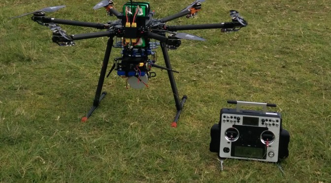
The Hornet™ II platform has been developed by V-TOL Aerospace to provide organisations requiring a survey (vertical & horizontal) and mapping capability, a CASA compliant, fully supported, low-cost, easy to use and reliable < 25kg class electric Multi-Rotor (MR) RPAS. Hornet II is E-VLOS operations ready. The images can be processed post-flight to produce mm/cm accurate colour/multispectral mosaics. When used in conjunction with other tiers of mini-RPAS, such as the Goshawk Fixed Wing system, the Goshawk can provide broad area coverage (see Goshawk brochure for more information) while the VTOL system can be deployed to identify a specific target of interest to mm resolution.

Description
Airframe
Developed using high strength yet light weight carbon fibre materials, has 6 power plants to provide a stable & redundant platform for airborne day operations < 400ft AGL. It is designed to be easily packed for ground vehicle or commercial airliner “flyaway” operations including batteries. It is fitted with LEDs for night navigation, as an option.
Mission payloads
The Hornet™ in the survey configuration carries hi-res 24 (optional 36) megapixel colour camera mounted on a 2-3 axis brushless gimbal with on-board storage for post flight processing. This configuration allows for stabilised mapping of horizontal and vertical assets. A multi-spectral payload can also be fitted for environmental survey or agricultural applications. A LIDAR payload is also available for large area LIDAR modelling.
A live video feed is also provided to the dedicated VDU/Ground Control Station (GCS) and/or via the V-TOL iView video receiver DVR.
Guidance and Control

Hornet™ utilizes V-TOL proprietary auto-pilot software known as “V-TOL Neuron™”. This program enables manual, stabilized and semi-autonomous ‘point and click’ computer operations. Options are included to enable easy to configure linear and area survey missions.
To achieve CASA compliance as a training system, Hornet™ Neuron™ has demonstrated and is capable of executing multiple fail safe responses. Such fail safes are designed to protect the RPAS and third parties from any system failures. Hornet is controlled by a frequency hopping spread spectrum 1W diversity switched digital link, with upgrades to AES Encryption available.
Also Included is the Ground Control Station (GCS) box containing Toughbook Laptop, Transmitter, Video Receiver and 2 batteries. Further GCS/Aircraft inclusions can be discussed during the purchasing phase.
Hornet™ for Survey and Mapping
Camera Systems – The Basic Surveyor and Mapping aircraft can be fitted with either the Sony Alpha A6000 24MP still imaging camera, or the Micasense Rededge Multispectral Camera. Support for additional optical and multi-spectral camera packages may be accommodated depending on size and weight.


LIDAR System – The LIDAR Mapper aircraft is fitted with a custom LIDAR payload capable of 100m range to survey a complex 360 degree sphere environment.

Video Downlink – Options for the surveyor and mapping aircraft include the ability for either a standard definition analogue video transmission (5.8GHz @ 25mW to meet ACMA restrictions) coupled with a diversity ground receiver fitted with high gain antennas for up to 3km video range.
Further options include a HD capable digital AES encrypted video link (2.4 GHz @ 100mW) coupled with a diversity ground receiver fitted with high gain antennas for ranges from 2km up to 10km.
Specifications
Dimensions & Weights
Diameter 1000mm
Height 600mm
Weight Empty 5kg
MTOW 25kg
Performance
Max Level Speed 20Kts
Max Wind Speed 20Kts
Operational Height <5000ft AMSL
Mission Radius <3km (BVLOS/Night ready)
Endurance 18 – 30 minutes (Subject to weather and payload)
Contact us to find out more!